Sunday 13 July 2014
ULTIMATE COURTSHIP ON A 1mm WIRE
Sunday 6 July 2014
TRANSPARENT TADPOLES VIDEO
 This is the first report of transparent tadpoles in the Uttarakhand Himalayas. These tadpoles belong to the species Microhyla ornata. The internal organs of these tadpoles are visible due to its transparent nature. The presence of these tadpoles in pools are revealed only at certain times of the day when the sun shines at a special angle. Otherwise, they are not seen and gets merged with the colour of water. The groups of tadpoles immediately sink to the bottom of the pool when disturbed. This particular species was found in a small pool in District Pithoragarh by a forest officer, Mr.Manoj Chandran IFS, who was serving as a Working Plan Officer of Pithoragarh Forest Division in the year 2011-12.
Tuesday 24 December 2013
THE KEDARNATH DISASTER - The FACTS

Possible causes of
the Disaster
The disaster has probably
occurred due to a Glacial Lake Outburst Flood (GLOF) of Chorabari Lake
(otherwise known as Gandhi Sarovar), triggered by a cloud burst, i.e, an
intensive rainfall in a very short period of time where the rate of fall of
water is much more than what the land can absorb, causing enormous runoff
causing a huge mass of soil and debris to be carried along with the flow. The
cloud burst would have caused the glacier lake Gandhi Sarovar (Chorabari lake)
to overflow or breach as is evident from the ISRO Bhuwan imageries pre and post
flood. The catchment area of Kedarnath above the shrine is around 3000 ha and
even 10mm of rainfall would mean a collection of 3 lakh cubic metres of water.
If such a 10mm rainfall occurs in a span of one hour, all this water would be
run off without having time to be absorbed by the soil. The wide catchment area
above the shrine abruptly narrows down into a deep gorge the bottom of which is
the trek route from Gaurikund via Rambada to Kedarnath along the Mandakini
river. This might have caused all the
water to flow into the narrow gorge thereby raising the level of the river by
several metres above the normal flow. The continuous rains and a probable cloud
burst induced GLOF might have triggered several landslides and mass movement of
the glacial debris of the Chorabari glacier situated a few kilometres above the
shrine and caused siltation of the shrine premises and the force of the flowing
mass caused destruction of buildings and property that came in its way. The
velocity of flowing water accelerates due to gravity as it moves down from
3550m at Kedarnath shrine to less than 2000m at Gaurikund.

Google image of
Kedarnath trek route and surroundings as on 19/3/2012
How is the phenomenon different from normal scenario
Kedarnath shrine is situated at
about 3550m above mean sea level and is well above the treeline which is around
3300m. The areas above Kedarnath are snow capped mountains and the Chorabari
glacier. There are several glacial lakes also in this area including the
Chorabari lake (commonly known as the Gandhi Sarovar) and also the Vasuki tal
in the adjoining catchment of Vasukiganga. This area, because of the high
altitude remains usually above the normal height of clouds and only receives
rain sprinkles or light rains most of the time during the monsoons and mostly
the precipitation is in the form of snowfall. The area being devoid of tree or
shrub growth due to its altitude does not have any cushion to reduce the force
of the falling rain. The snowy glaciers are even devoid of grassy meadows in
most of its area. This season, the area experienced heavy rain instead of
sprinkles and hence the GLOF might have occurred.
Is Deforestation the
cause of disaster
No. All the tree cover area from
near Rambada to Gaurikund are part of the Kedarnath Wildlife sanctuary where
the protection of forests is well ensured. The areas above Rambada slowly and
naturally has a reduction in tree growth as one goes up and merges into the
alpine meadows at around 3 km before Kedarnath. The forest cover of the State
has increased by 1% in the last decade as per FSI reports.
Are Dams the cause of
disaster –
There are no dams in the
Kedarnath valley from Kedarnath to Kund. Dams are allotted to the States after cumulative EIA of the
Watershed. The actual construction
begins after EIA and environment clearance from Ministry of Environment and
Forests, Government of India. Further,
the design and safety aspects have to be cleared by the Dam Safety Organisation
in Government of India. In fact, a properly designed dam can actually prevent
flood damage as it can bring down the velocity of water to a great extent
thereby reducing the force. Central Water Commission has also said that Dams
prevent floods. Most of the damage in other valleys where dams are present are
in the upstream of such dams and very less damage is reported from downstream
of the dams.
Are illegal
constructions cause of disaster
Construction in Kedarnath valley
is restricted to only three places, viz., guest houses and hotels in and around
the shrine, a small cluster of shops and houses at Rambada and a larger
congregation of buildings, horse stand and parkings at Gaurikund. The
pilgrimage attracts a lot of people from all over the nation and also abroad.
The large in flow of pilgrims cannot be regulated due to religious sentiments.
In order to provide accommodation and food to the pilgrims especially during
the peak season, it is inevitable to have adequate facilities at the starting
point, mid point and the end point of the trek, viz. Gaurikund, Rambada and
Kedarnath. Since it is a narrow gorge along the river Mandakini, there is no
other space for any construction activity other than the present settlement.
The increase in construction
activity is not the cause of disaster, however, it can be interpreted that loss
of property would have been much less had these constructions not been there.
The persons on the top storeys of multi-storeyed buildings have survived the
disaster to a great extent, whereas most of the temporary constructions have
been affected.
Post disaster there needs to be a
relook at implementation of the Forest Conservation Act (so that endangered
villages can be shifted to safer areas, including in forests where necessary
(after following the procedure for diversion of forest land), enactment of
building byelaws and zoning regulations for the entire State, capacity building
in the area of urban planning (including kshetra panchayats etc) and for
evolution of earthquake proof and flood resistant constructions. There needs to
be rellok at lifting of material from river beds (to lower the level of the
bed) and also integrated river training activities.
Mining
There is no mining activity in
the Mandakini river from Kedarnath to Kund. Only a few boulders and sand is
picked up for local construction by the villagers from silted banks of the
rivers, which get silted up every year during the monsoons. The periodic
removal of silt also helps to streamline the course of the river which
otherwise would get diverted from time to time, eroding more of its
streambanks.
Eco sensitive zone
objection
There is a rumour that
Uttarakhand government and the people have objected declaration of eco
sensitive zones. Actually, the State and its people are in favour of having
regulated and planned development of all its areas and is willing to declare
the area as an ecosensitive zone. The recent objection raised was against the
unilateral way by which the Ministry of Environment and Forests(GoI) imposed
several restrictions in the name of an eco sensitive zone in the Bhagirathi
valley without consulting the State government or conducting any stakeholder
consultations with the villagers. The Bhagirathi notification also contained
many lacunae in addition to declaring more than 100 times the area intended to
be declared in the draft notification. This defeats the very purpose of the
initial notification, is against the principles of Natural Justice and is bad
in law. The final notification was hidden from public view and was put on the
web only after four months of the notification. There was also confusion in the
EIA notification where it has regulated activities even in 10 km vicinity of
any eco sensitive zone.
Green bonus
The State is providing eco system services to the rest of the
nation,which has been computed to be around Rs.27,000 Crores per annum by
Indian Institute of Forest Management, Bhopal
for which the State has requested assistance from the Central Government
in the form of a Green Bonus for the
maintenance of these services.
Ecological
responsibility of UK vs other states
The people of Uttarakhand has
preserved and conserved its forest and environment at the cost of losing
opportunities of economic and infrastructure development and also industrial
growth. The other States have already torn down their forest and vegetation for
rampant industrial development.
Rain instead of snow
– climate change due to fossil fuel burning and industrialisation
The thermal and coal based power
plants and heavy vehicular traffic in the plains of India, especially the
industrialised States has caused large scale emission of green house gases
which has resulted in global warming as a result of which the average temperature
in the snow bound areas are also increasing causing rain fall instead of snow
fall as it used to occur in the past. Rain fall instead of snowfall also causes
the existing permafrost and glaciers to melt and cause avalanches and
landslides and their flow along with the flash floods causing major havoc
downstream.


Pictures of Rambada
before the disaster (This settlement is not even traceable at present and is replaced by a debris laden gorge.)
Sunday 20 October 2013
The costliest medicinal herb of Himalayas - Yartsa Gambu / Cordyceps sinensis
 Yar-tsa Gam-bu or the Chinese caterpillar mushroom (Cordyceps sinensis) is the costliest medicinal herb of the Himalayas. It is an entomophagous fungi, Cordyceps sinensis growing on the caterpillar of a moth of the Genus Hepialus. It is collected at an altitude above 3800m during the month of June when the snow melts and the fruiting body of the fungi just emerges out of the soil from the mouth end of the dead caterpillar. Around 3000-4000 pieces makes one kilogram of produce which costs between INR 2.5 lakh to 10 lakhs depending on the grade of produce, demand and supply.
The main use seems to be by atheletes as the drug is not detected in dope tests. Just before the London Olympics, the rate was upto INR 10 lakhs/kg in the Kathmandu market in Nepal. The trade route is from Kathmandu to Hongkong and then elsewhere in the world. The produce is found throughout the Himalayas in India, Nepal, Bhutan and also in Yunnan and Sichuan province in China. It is also supposed to be a cure-all herb and is widely used in Chinese and Tibetan medicine.
Monday 29 August 2011
All set for Kangdali festival - SIRKHA VILLAGE
 Sirkha village, the centre point of Chaudans valley of Pithoragarh is all set for the Kangdali festival in early October. Kangdali is a herb, Strobilanthes wallichii, which flowers once in 12 years. This bushy herb was once said to be used by attacking Zorawar army of Ladakh to hide from the villagers. The women folk of the village found these soldiers and drove them away by striking the bush with sticks. The incident is still remembered during the festival when women beat and destroy the bushy herb, at least symbolically.
  The Chaudans valley consists of erstwhile 14 villages in Dharchula tehsil of Pithoragarh, Uttarakhand, India, which now have split and increased in number. Sosa, Sirdhang, Sirkha, Pangu, Himkhola, Chalmachilason, Pulnabhatka, Rung, Samri, Kurila, Bangpa, Jaikot, Shankhola, Gipti, Tankul, etc. are the major places of importance in this valley.
Most of the population belongs to the Rung community. This valley falls in the traditional route to Kailas Mansarovar trek route through Indian territory.
Thursday 18 August 2011
VIDEO - ROAR OF THE VALLEY - ASKOTE WILDLIFE SANCTUARY
This is a video of the Umchiya gad, a tributary of Dhauliganga East River in the Askote Wildlife Sanctuary, Pithoragarh, Uttarakhand, India. The stream is roaring in its full strength during heavy rains in the valley. PUT YOUR COMPUTER VOLUME FULL for full effect of the ROAR.
Monday 25 July 2011
MOST BEAUTIFUL WATERFALL IN ASKOTE WILDLIFE SANCTUARY

This is the Kanjoti waterfalls situated in the Askot Wildlife Sanctuary, Pithoragarh, Uttarakhand, INDIA. It is at an altitude of 1500m near the Dhauliganga river cutting through the greater Himalayas. There is a hydro-electric project also run using the head of this waterfall. The waterfall is at its best during the monsoons from July to September.
Sunday 24 July 2011
TICKS on ROCK LIZARD
 Click on the image to enlarge. You can see that there are a lot of large blue coloured ticks hanging on to the body of the lizard, especially near the eardrum. This photo is from the Askote Wildlife Sanctuary in the Himalayas in the state of Uttarakhand, India. It is a rock Agama, probably Laudackia tuberculata. Kindly properly identify both the lizard and the tick species if anybody could.
Sunday 17 July 2011
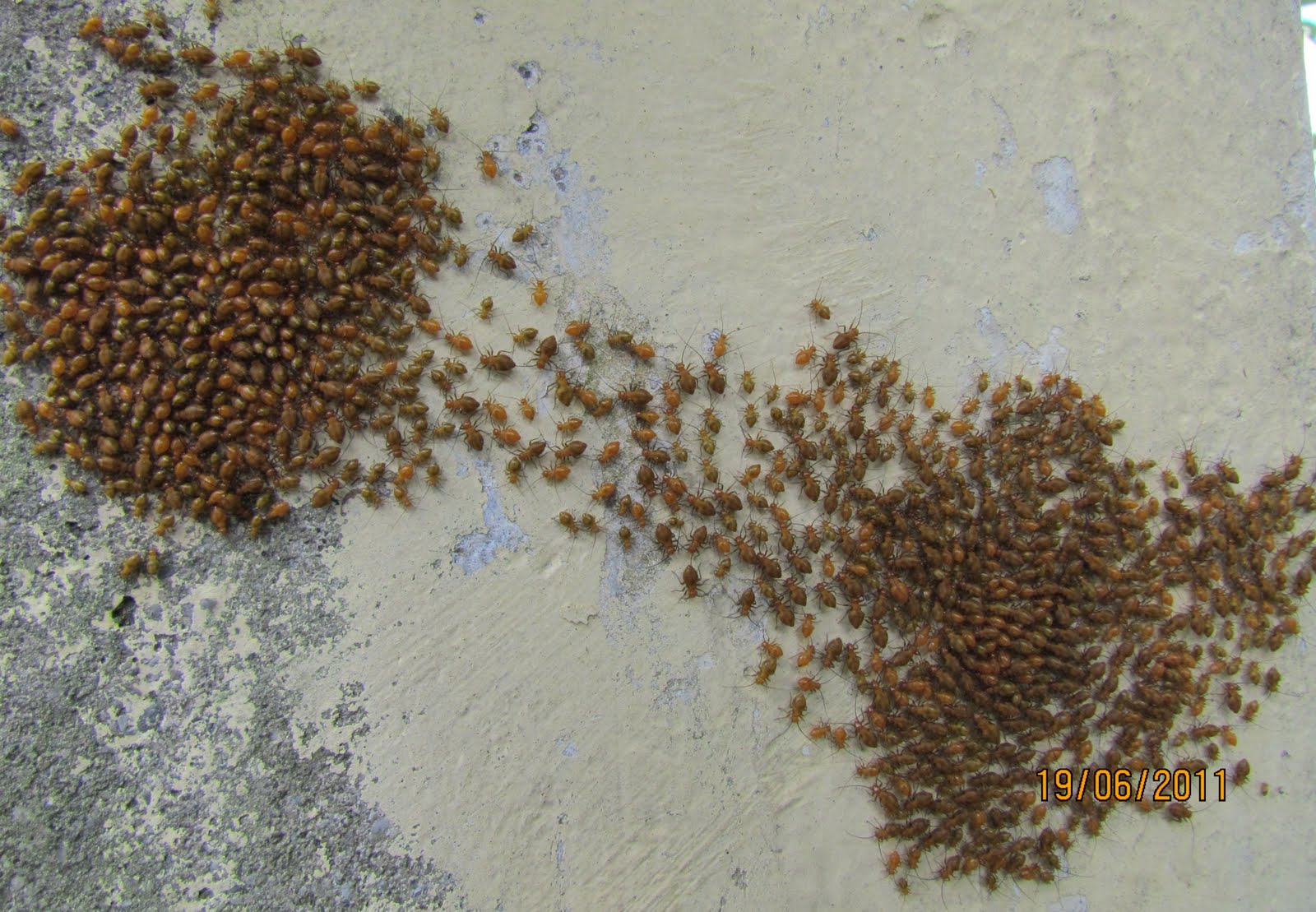
GIANT APHIDS GROUPING AND REGROUPING
 |
| BEFORE |
 |
| AFTER |
These bugs (looking like giant aphids) were aggregating and splitting into groups and repeating the process for a long time. Could anybody explain the phenomenon and also identify the species? Some of them had wings too, may be the males.
THE MOST BEAUTIFUL PLACE ON EARTH
 |
| Jimba - A rather unexplored subalpine meadow in the Uttarakhand Himalayas |
This is the rather unexplored Jimba meadow in Munsyari Tehsil of Pithoragarh. It is enroute the traditional Kailash route not used nowadays except by the people of Munsyari and Dharchula. It is a two day walk from Sobala near Dharchula or from Bauna near Madkot. The area is rich in Musk deer and Himalayan Black bears in addition to the other diverse flora and fauna.
Subscribe to:
Posts (Atom)